|
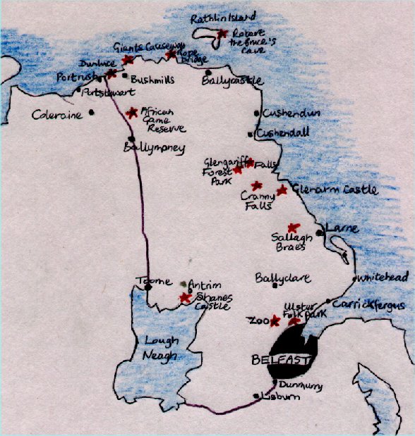
Information on County Antrim County Antrim contains the capitol of Northern Ireland, Belfast. It also contains some spectacular scenery. To the north the glens of County Antrim run down to the sea, and near the northern tip lies one of the wonders of the world, the Giants Causeway. Ballycastle Ballycastle is the largest market town in the Antrim glens. It hosts the Ould Lammas Fair, Ireland's oldest fair and probably most popular. It has been held sine the 1400s and at first near Duineny castle , since the name means the "fort of the fair". The castle ruins are now scattered on the cliffs of the bay. the fair takes place on the last Monday and tuesday of August in the towns centre, or Diamond. There are stalls with all sorts of produce and also livestock sales. Bally castle built up around a castle built in 625 by Sir Randal MacDonnell in the Diamond area of the town. The town was industrialised in the 18th century by the local landlord Hugh Boyd. He built the Protestant Holy Trinity church in 1756. It contains memorials to the Boyd family. During this time the town manufactured glass, soap, salt and iron using the local collieries , now disused. Ballycastle has a good sandy beach and a modern harbour. there is a memorial at the harbour to Count Marconi and his assistant George Kemp as from Ballycastle they established radio contact with Rathlin Island in 1898, and with the Coastguard station at Torr Head. Belfast Belfast is the capitol city of Northern Ireland and is a large bustling place. It was an industrial city, with ship-building, linen, ropemaking and tobacco industries based here. St.Anne's Cathedral
The Cathedral opened its doors in 1904 and its Neo-Romanesque facade is not
very exciting to see. Inside however there are several things worth
looking at. Two mosaics made by the misses Martin in the 1920's The
one in the baptistery uses over 150,000 pieces. The nave is canadian
maple and the aisles are Irish marble. Botanic Gardens The Botanic Gardens back onto the University. The Palm house built in 1839 is a wonderful building of glass and cast-iron. The Fernery is a wonderful victorian design. City Hall Donegall Square in the heart of the city is the home of the City Hall. Built in 1906 of Portland stone, it has an elaborate tower at each corner and a central copper dome. Statues decorate the building, queen victoria standing by the main entrance and Sir Edward Harland founder of the Harland and Wolff shipyard stands on the east side.Nearby there is a memorial to those who died in the Titanic in 1912. Inside there is an oak-panelled council chamber. The Entries These are a series of narrow alleys between Ann street and High street. Some of the best pubs are found here such as white's Tavern the oldest bar in Belfast. In 1791 the United Irishmen was founded in a tavern on Crown Entry, its most famous member was Wolfe Tone. Grand Opera House The Opera Hose was designed by Frank Matcham a well known theatre-architect and opened its doors in 1894. It has a splendid interior of red plush , gilt and plasterwork. Bombings next door at the Europa hotel during the troubles have sometimes disrupted business, but it still survives as a major venue for plays and concerts. It was restored in 1980. Linen hall Library The Library has thousands of rare old books, genealogical information and also extensive documentation of political events in Ireland since 1968. It was founded as the Belfast Society for Promoting Knowledge in 1788. Above the door is the Red Hand of Ulster, the emblem of the province. It is a gory story, two celtic heroes were racing to see who could touch the land of Ulster first, in his determination to win one severed his own hand and threw it to the shore Queen's University Only 15 minutes walk from Donegall Square leads to Northern Ireland most important university. The main building designed in a tudor style by Charles Lanyon in 1849 looks similar to Magdalene College, Oxford. Stormont Stormont is based 8km (5 miles) south-east of the city centre. It was built between 1928 and 1932 to house the Northern Ireland Parliament. It is built of Portland stone and Mourne granite, and its Anglo-Palladian form stands at the end of a long avenue 1.6km (1 mile) avenue, surrounded by parkland. A statue of Lord Carson stands near the from entrance. The parliament was disbanded in 1972 and the building has been used as government offices. the debating chamber was badly damaged by fire in 1994. It is sometimes used for important meetings between heads of state, but its future lies in the outcome of the ongoing peace process. Ulster Museum The museum covers all aspects of Ulster history. There is archaeology, antiquities, local history, and natural history. The top floor contains paintings by British and Irish artists, including a number by Sir John Lavery (1856-1941) who was Belfast-born. There is a collection of jewellery and treasures recovered from the Spanish Armada ship "The Girona" which sank off the giants causeway. There are also dinosaurs, egyptian mummies, and much much more. Bushmills See:- Bushmills River Carrickfergus Carrickfergus grew up around the castle which was built in the 12th century (begun 1180) by John de Courcy to guard Belfast Lough. He was the leader of the Anglo-norman force which invaded Ulster. It overlooks the harbour and is one of the best preserved Norman Castles you could see. The Scots under Edward Bruce took over the castle in 1315, holding it for three years. In the 17th century James II's army was in control of the castle from 1688 until General Schomberg took it for William III in 1690. William stayed in the castle before the battle of the Boyne in July 1690. Arms and armour are on display here in the keep and there are life sized model soldiers posed on the battlements. Causeway Coast The most famous part of the coast is the Giants Causeway...see: The Giants Causeway To the west of the Causeway is Dunluce Castle, whose ruins sit perched on a steep cliff by the sea. A storm once blew the kitchen into the sea! It was built in the 13th century by the MacDonnells, chiefs of Antrim. It is reasonably well preserved with towers, gateway and cobbles still visible. Dunseverick Castle is an earlier built castle than Dunluce. It was once the capitol of the kingdom of Dalriada, linked with Tara. It was the base for raids on scotland in the 5th century. Only one massive wall remains now. you pass White Park Bay and its lovely sandy beach before getting to Ballintoy with its pretty harbour. There are boat trips from here to Sheep Island just off the coast in the summer, where there is a cormorant colony. East of Ballintoy is the Carrick-a-rede Rope Bridge. This scary bridge hangs 25m (80ft) above the sea and stretches the 20m (65ft) chasm between the mainland and the tiny island where there is a salmon fishery. Kinbane Castle is a ruin and little remains, but the views are spectacular. Cushendall Cushendall is sometimes known as the capitol of the glens as three of the nine glens of Antrim converge on the village. The Curfew tower overlooks the village and was erected in the early 19th century as a lock up for thieves. It is made of a distinctive red sandstone. 1.5 km(1 mile) north of the village is Layde Old church, founded by the Franciscans, it was a parish church from 1306 till 1790. It has many monuments to the MacDonnells, the local chieftains. 3km(2 miles) west of Cushendall lies Ossian's Grave, named after Finn MacCools son. It is on the slopes of the Tievebulliagh mountain and is in fact a Neolithic court tomb. It was a major tool making site in the stone age and many axeheads made here have been found all over the British Isles. Carnlough is a pretty village with lovely harbour and a sandy beach, Ballygally has a 1625 castle which is now a hotel. Glengariff Forest Park Glengariff Forest Park contains some of the most spectacular scenery of the glens of Antrim. There are nine river valleys that make up the glens. It was always a remote region and was not settled in the 17th century by the English and Scots. It was also the last place in Northern Ireland where Gaelic was spoken. there is a main scenic path and many other optional ones. there are waterfalls to see, woodland and wildflower meadows. Thackery, the 19th century novelist called the landscape "Switzerland in miniature". Larne The sheltered waters of Larne Lough have been a landing spot since Mesolithic times, flint flakes found here date back to 9,000 years ago and are the earliest evidence of humans in Ireland. Norsemen used the lough in the 10th century and Edward Bruce landed his Scottish army here in 1315. In 1914 The Ulster volunteer Force, landed a cache of German arms here during its campaign against home rule. Larne is now the arrival destination for the ferries from Scotland, and sadly is not a very pretty sight being an industrial centre. Rathlin Island It is 11 km (7miles) long and no more than 1.6 km (1 mile) wide and is shaped like a boomerang. About 30 families live on it and they make their living from farming, fishing and tourism. It has virtually no trees because of the fierce, salty winds that whip across the island. Most of the island is surrounded by high white cliffs, at Bull Point at the westerly tip there are thousands of seabirds nesting, puffins, kittiwakes, razorbills and gulls. At the easterly tip is Bruce's Cave, where Robert Bruce in 1306 is reported to have watched a spider climbing a thread. The spiders perseverance inspired the dejected Bruce to return and win back his kingdom. |